Heading north out of San Francisco on 101 we cruised through the town of Petaluma and drove out Bodega Highway, past fields of cows (smell that dairy air, says Holly), with sheep and goats grazing in pastures still green. At Bodega Bay we turned off towards Bodega Head and stopped at Fisherman’s Cove across from Spud Point Marina for oyster po-boy, fish tacos and an IPA we hadn’t tried—Bodega Head from Third Street Brewery in Santa Rosa (highly recommended).
Bodega Head (the place, not the beer) has always been one of our favorite stops. In the 1950s, PG&E made ill-conceived plans to build a nuclear power plant here, and the exploratory hole they dug—before concerned citizens stopped the project—remains. Fondly known as the Hole in the Head, it is now a deep fresh-water pond, home to many species of birds. Continuing up over the ridge to the bluffs, you can park, roll up the windows against the chill wind, and watch the ocean from the shelter of your vehicle. Or you can walk over and chat up the whale guy sitting in his chair above the point to see how many whales have been sighted. We chose to walk the path up to the head along vertical cliffs that plunge to the crashing waves hundreds of feet below. Orange cones mark a section of trail that had fallen in, reminding us of the two hikers caught by a slide at Point Reyes just the week before. This is a landscape constantly changing.
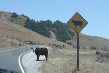
After our hike we returned to our car and continued on up the coast. There is a part of Highway 1 up above Jenner and Meyer’s Grade where cattle roam freely across the road.By that time, the road is so twisty that there is little chance of hitting one as you are driving so slowly.
 Besides, the driver must allow herself to sneak a peek at the sparkling ocean every so often. Salt Point State Park goes on for miles, a tempting stretch of ocean-side wilderness that we had to pass up this trip. We drove past the store at Stewart’s Point and breathed a small sigh of relief as the road straightened out a bit, knowing our destination was not far now. The last ten miles of highway approaching Gualala bisect the development known as the Sea Ranch, which itself has an interesting history as early controversies around the planned development in the 60’s and 70’s resulted in the creation of the California Coastal Commission, whose mission is to “protect, conserve, restore, and enhance environmental and human-based resources of the California coast and ocean for environmentally sustainable and prudent use by current and future generations.” The commission regulates all development along the coast and ensures that our ocean and beaches are not privatized but remain accessible to the public, something we deeply appreciate. Passing by Sonoma County Regional Parks northernmost outpost, Gualala Point, we finally drove over the Gualala River. When you cross the bridge and arrive at the town of Gualala on Highway 1, you have reached Mendocino County.
We have explored many beaches and parks in this area, but had never been to Bowling Ball Beach in Schoo ner Gulch State Park north of Gualala. You can’t drive in, but must park alongside the highway where a sign asks that you park facing south. To get to the beach we walked a short distance along a wooded trail and then had to let ourselves down the last section of cliff with a rope left by some kind soul, as the steps had been washed out by a previous storm.
What we found was totally cool. For starters this is a spectacularly beautiful beach, where we observed pelicans in formation cruising low over the  waves, great blue herons snatching their breakfast from the tide pools, and an osprey wheeling overhead.
But the unique feature of this beach is the dozens of “bowling balls” littering the shore as well as the platforms of smooth, level rock they lie on which look very much like bowling lanes, or maybe an airport runway.


The bowling balls are spherical rocks about 2 to 3 feet in diameter. They were formed as concretions which (according to Wikipedia) are hard, compact masses of matter formed by mineral cement within the spaces between particles, often ovoid or sph erical in shape. They were created within the sandstone cliffs rising above the beach, and as the ever-encroaching waves erode the sandstone these harder rock balls fall to the shore below, resulting in an amazing landscape.
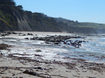

We had timed our visit to coincide with low tide, and were rewarded with an expanse of tide pools to be explored. They were filled with crabs of various types, anemones, small fish, and various colorful plant life but alas, no sea stars (starfish) as they have recently died off in great numbers by a mysterious wasting disease. Beyond the tide pools at the north end of the beach, a path climbs up to the bluff with a spectacular view of the ocean below.

By the time we finished exploring this unique landscape we had worked up an appetite, so we returned to our car and headed north to one of our favorite lunch stops as well as other places to explore near the town of Point Arena. Stay tuned for the further adventures of MoHo on the MendoSonoma coast…
By Molly Martin and Holly Holbrook
